An-30
Antonov
Historical Context & Origins
The Antonov An-30 emerged from a specific strategic need of the Soviet Union in the 1960s: the demand for a specialized aircraft for high-precision aerial mapping and monitoring of vast territory. Its development, led by the expert Antonov Design Bureau, represented a logical evolutionary step, building on the proven and robust An-24/An-26 tactical cargo platform.
This innovative project aimed to provide a robust and reliable solution for large-scale topographic, geological and environmental investigations. The first flight of the An-30 occurred in 1967, marking the beginning of a long and distinguished career dedicated to science and surveillance. Its concept responded to the need to integrate complex aerial photography and navigation systems into a single dedicated platform.
Architecture & Technological Design
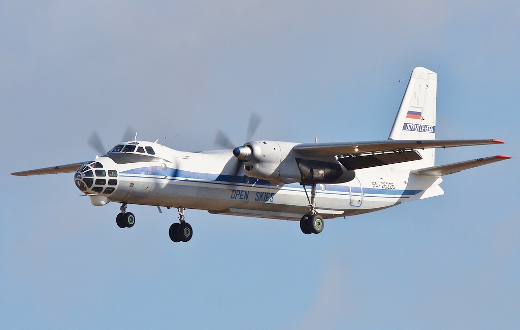
The An-30 was immediately distinguished from its An-24/An-26 base by a markedly redesigned architecture for its specific role. The most obvious and iconic modification was the replacement of the original nose with a glazed and elongated front section, optimized to accommodate an advanced navigation and observation station, fundamental for the precision of the missions.
Under the fuselage, the aircraft integrated dedicated bays for aerial cameras, equipped with retractable hatches to protect the instruments during flight and ensure their optimal functioning only when necessary. This configuration allowed the simultaneous installation of different types of sensors and photographic equipment, capable of acquiring cartographic and geodetic data with extreme accuracy.
The An-30 also incorporated sophisticated onboard electronics for its time, including inertial navigation systems and precision radio altimeters. These instruments were crucial to maintaining the exact trajectory and altitude required for aerial photography, allowing the aircraft to perform its complex operations with extraordinary repeatability and reliability.
Onboard Specifications
- ◆Redesigned Glass Nose: An iconic navigation and observation station, featuring multiple windows and a lower glass bubble, for optimal terrain vision and support for precise navigation.
- ◆Multiple camera bays: Strategically positioned under the fuselage, they could accommodate up to five aerial cameras simultaneously, of different focal lengths and formats, to cover large areas or specific details.
- ◆Advanced Navigation and Positioning System: Included an instrument complex that combined navigation radar, radio altimeter and an analog/digital calculator to ensure maximum accuracy in positioning and flight path required for mapping.
Operational Career & Operators
The Antonov An-30 quickly became the workhorse for aerial reconnaissance missions throughout the Soviet Union and, later, in the CIS countries. Operated primarily by the Soviet Air Force and civilian mapping agencies, the aircraft played an irreplaceable role in creating and updating topographic maps of vast regions.
In addition to its primary functions of mapping and geological survey, the An-30 has also found use in delicate environmental monitoring missions and research operations. La sua robustezza e la capacità di operare da piste semi-preparate lo rendevano versatile e idoneo a coprire territori impervi, consolidando la sua reputazione di aereo da lavoro instancabile.
One of its best-known applications, especially in recent times, was in the context of the Treaty "Cieli Aperti" (Open Skies). The An-30 has been used by several nations, including Russia and Ukraine, for unarmed mutual observation flights, demonstrating its continued relevance and ability to play a key role in international transparency.
Legacy & Cultural Impact
The Antonov An-30, with its unmistakable silhouette characterized by the glass nose, is more than just a plane; it is a symbol of scientific precision and international cooperation. It has contributed significantly to the geographic and geological knowledge of entire nations, providing vital data for infrastructure development, agriculture, and natural resource management.
Its operational longevity, with many examples still in active service more than half a century after first flight, is a testament to the excellence of its design and Antonov's engineering foresight. The An-30 forged a legacy of reliability and specialization, proving that an aircraft with a well-defined purpose can exceed expectations and remain relevant for decades.
In an era dominated by satellites and drones, the An-30 continues to demonstrate the unique value of direct aerial observation, offering an irreplaceable and detailed perspective. Its impact goes beyond mere data collection, contributing to a greater understanding of our planet and facilitating diplomacy through tools of transparency and mutual trust.
Telemetria Specs (HUD)
Hangar Trivia & Curiosità
- 💡È facilmente riconoscibile dal suo 'fratello' An-24 grazie al muso esteso e vetrato, che ospita il posto di lavoro del navigatore e le apparecchiature fotografiche specializzate.
- 💡L'An-30 opera tipicamente con un equipaggio di 7 persone, che include piloti, un navigatore, un ingegnere di volo e operatori delle telecamere.
- 💡Alcuni An-30 sono stati convertiti per la ricerca meteorologica e il monitoraggio atmosferico, equipaggiati con sensori e strumenti aggiuntivi per lo studio del clima.
Archivio Avvistamenti Spotter
Immagini scattate dalla community in tutto il mondo